Our Pause-Midi talk by Eric Thierry on January 17, 2024
It is impossible to be in northern New England or Québec without being aware of Samuel de Champlain. In Vermont, nothing less than the lake we share with New York is named after him (so named by himself), and throughout the region and especially in Québec, his name is ubiquitous. He has been the subject of innumerable historical accounts, as well as the key feature in historical fiction of the region. He has been praised as a supporter of Indigenous populations and as one more example of exploitative European colonialism.
This focus on him derives in large part from the extensive explorations that he undertook along coastal New England and Canada, the St. Lawrence riverine system, and the Great Lakes during the first three decades of the 17th century. It also derives from the extensive reports (relations) that he wrote, most of which were published at the time. His writings concern his travels, his attempts to establish French settlements, his efforts to find a northwest passage to the Pacific, his relationships with Indigenous groups, notes on the customs of those natives, and the geography of the regions, including extensive information on coastlines, topography, flora, and fauna. They also provide a fascinating portrait of him, one of the rare ones for an early North American explorer.
The extensive writings of Champlain (edited recently by Eric Thierry in Les Oeuvres Complètes de Champlain, 2019) read like a combination of adventure story, grant proposal, field report, political intrigue, and autobiography. They also lead to wondering what motivated Champlain for a third of a century to endure physical hardship, military conflicts, bureaucratic squabbling, and uncertainty. The January 2024 Pause-Midi talk (Champlain et le Chemin de la Chine) by Eric Thierry (an historian in Laon, France and a well-known scholar of Champlain and his contemporaries) focused on Champlain’s lifelong desire to find an overland (or riverine and lacustrine) route from the St. Lawrence estuary to the Pacific.
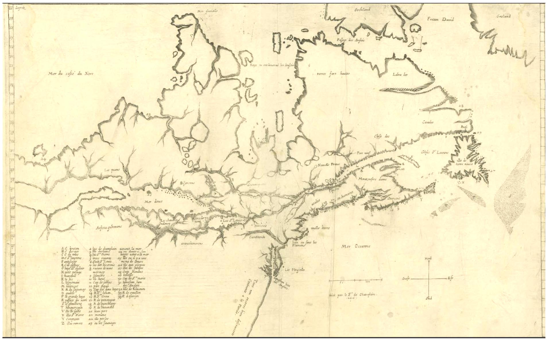
The talk by Thierry followed Champlain through his life, starting with his development in Brouage (coastal Saintonge) in a maritime family, his period in the French military in Brittany, and his development of extensive maritime skills. He became especially noted for his artistic abilities, which translated into his skill at cartography. Although he was to produce ethnographic drawings of native peoples and depictions of battles against the Iroquois, it was his maps (detailed drawings of lakes, rivers, harbors, and bays as well as overall maps of eastern Canada) that established his reputation and opened doors for him.
Thierry described the widespread interest in Europe during the 16th century in finding a shorter and faster route to the riches of China, namely one through or to the north of North America (the Northwest Passage). Champlain had available to him in Paris extensive reports and especially maps from previous European explorations. These documents formulated in his mind routes to the northern sea (largely Hudson Bay) or, via poorly defined lakes and rivers, to the Gulf of California. Champlain’s subsequent explorations northward up rivers along the St. Lawrence were largely focused on reaching the former, whereas his travels to the west (beyond Les Rapides de Lachine adjacent to Montréal) were oriented at the latter.
Using a combination of modern maps and satellite views of eastern Canada, combined with excerpts of Champlain’s writings and especially his maps of region, Thierry chronicled the sequence of voyages that Champlain undertook from the end of the 16th century through the first quarter of the 17th century. The initial ones included Champlain’s voyage with the Spanish around the Caribbean and to coastal Mexico in 1598–1600, and then his series of trips to coastal Canada and New England. The latter included the disastrous winter on the Île Sainte-Croix (New Brunswick and Maine, 1604–5), the more successful settlement at Port Royal (Nova Scotia, 1605–7), and coastal surveys down to New England coast as far as Martha’s Vineyard (1605–6, including the mapping of Plymouth harbor, 14 years prior to the Pilgrims).
Thierry then focused on the voyages that Champlain undertook up the St. Lawrence Seaway, in a sequence of voyages from France from 1608 to 1611, in 1613, and from 1615 to 1618. The initial trips were focused on finding routes to La Mer du Nord (Hudson Bay), initially up the Saguenay to Lac Saint-Jean (1608), then up the Outaouais as far as the Île des Allumettes (1613). Both the Saguenay and the Outaouais required passing multiple rapids, but his progress north up each river was ultimately halted by Indigenous groups (especially middlemen on the lucrative fur trade) not wanting the French to proceed further. He never reached Hudson Bay, despite his proximity to it.
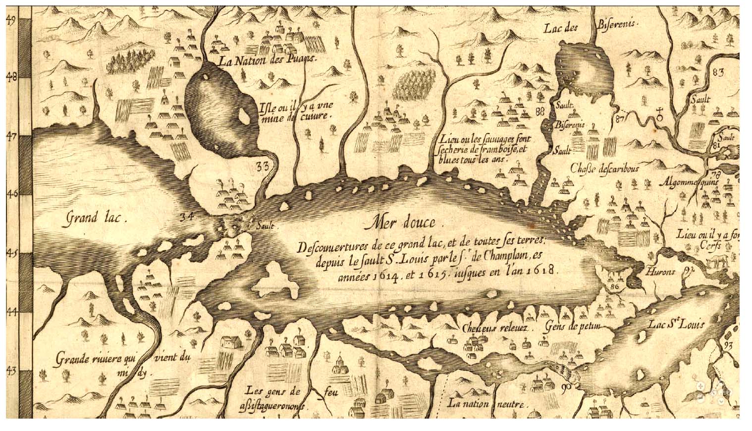
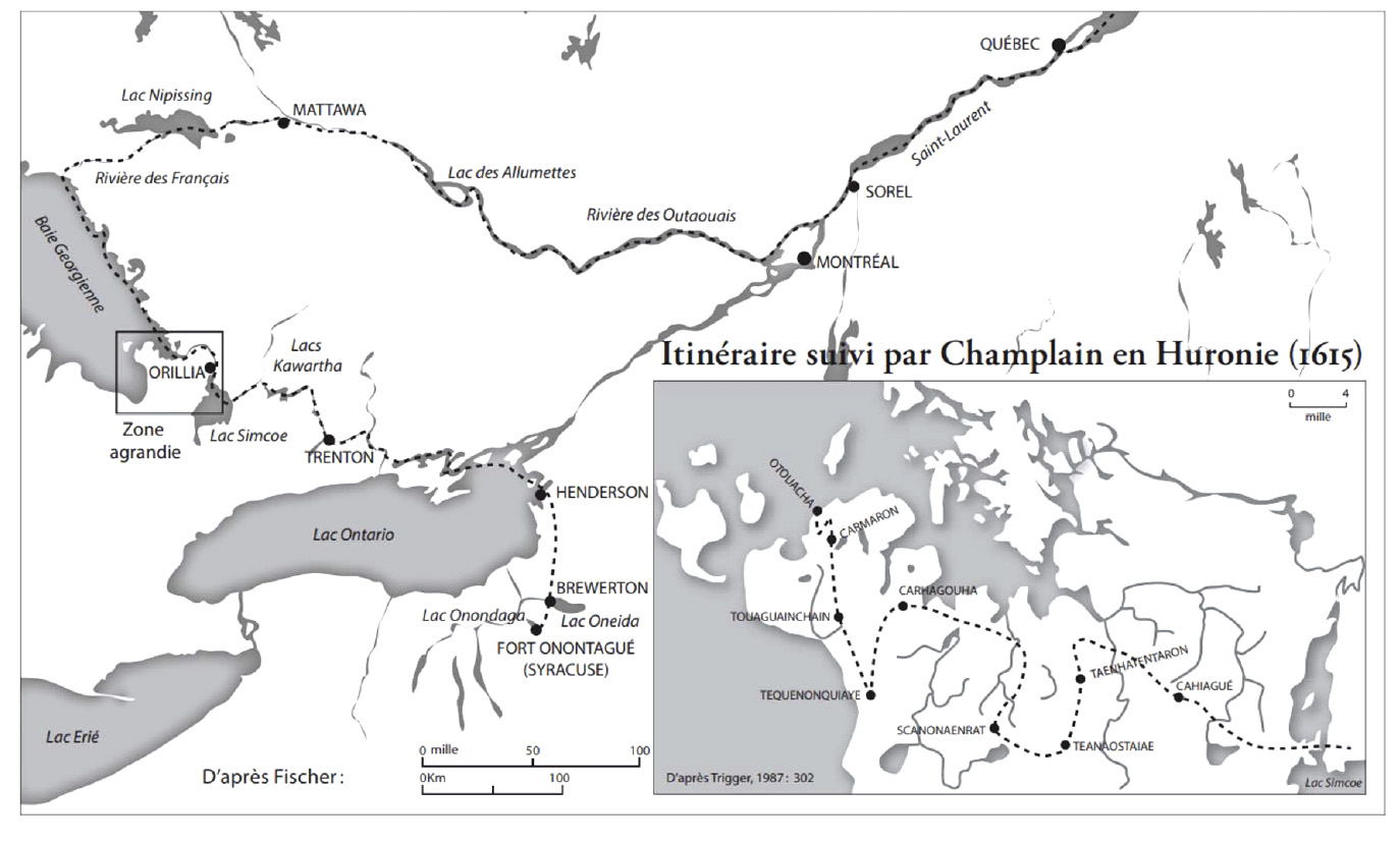
As important, his initial trip west on the St. Lawrence as far as Les Rapides de Lachine (initially a barrier, until passed with native canoes) brought him stories of the Great Lakes from local guides. One lake, beyond a freshwater one (Lake Ontario), was reputed to have other than fresh water (Lake Huron), stirring Champlain to see it as saline and leading to the Pacific. It was ultimately in 1615 that Champlain reached that water, along the shore of Georgian Bay and among the Hurons. He spent the 1615–16 winter with the Hurons, recovering from wounds, getting lost in the woods, and collecting extensive ethnographic data. Yet he was not to venture farther west from there.
Champlain was to spend his remaining voyages to Canada in and near Québec City (1620–24, 1626–29, and then 1633 to his death in 1635). It would remain to younger Frenchmen (coureurs des bois) sent by Champlain to proceed farther along the Great Lakes and report back to Champlain in Québec (Étienne Brulé in 1623 and Jean Nicollet in 1633). It was their reports of lakes and rivers to the west and southwest that would convince Champlain that he had indeed found the beginning of a route to China.
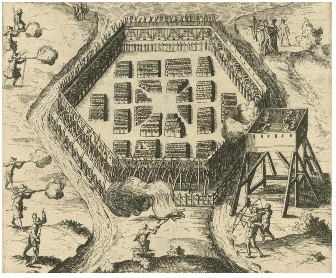
Thierry also described the three battles between the Champlain’s Algonkian allies and the Iroquois to the south. In each, Champlain and his men, with arquebuses, brought firepower to the fights, changing the traditional balance of power. They were part of Champlain’s strategy to build alliances with the Algonkians, despite his frequent attempts to bring peace in some form to the region. The first was the well-known skirmish at Ticonderoga in 1609, and the second was an attack on an Iroquois village at the mouth of the Richelieu River (1610). The third was near Lake Onondaga with the Hurons in 1615, and it resulted in defeat and injuries to Champlain. Each of these skirmishes was illustrated by Champlain, and his drawings have become iconic to the Champlain story. Although secondary to Champlain’s quest for le chemin de la Chine, these battles and extensive negotiations with Indigenous groups served to facilitate his explorations and settlements.
In his talk, Thierry focused on Champlain’s lifelong quest to find the Northwest Passage to China, and he attributed the various other activities of Champlain in La Nouvelle France as building toward that one goal—establish a route from China and build settlements and facilities to enhance the ultimate trade. One can debate whether that quest was all consuming for Champlain, or whether he saw La Nouvelle France as more than just a stepping-stone to the Pacific. What is nonetheless clear is that Thierry has helped to bring to life and made available many aspects of Champlain and his 17th-century world, and we were fortunate to have him present it to us as a Pause-Midi.
For those interested in hearing Thierry talk further about Champlain, he will be giving a talk to the Alliance Française du Maine on March 6 via Zoom entitled “Samuel de Champlain in Acadie.” It will focus on his 1604–7 explorations of the Nova Scotia to Cape Cod coast. It is free and open to all. To obtain the Zoom link, register here.
—Erik Trinkaus